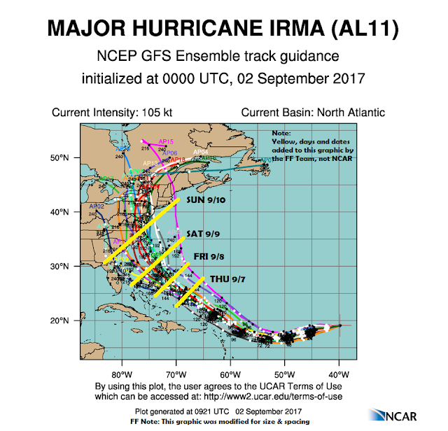
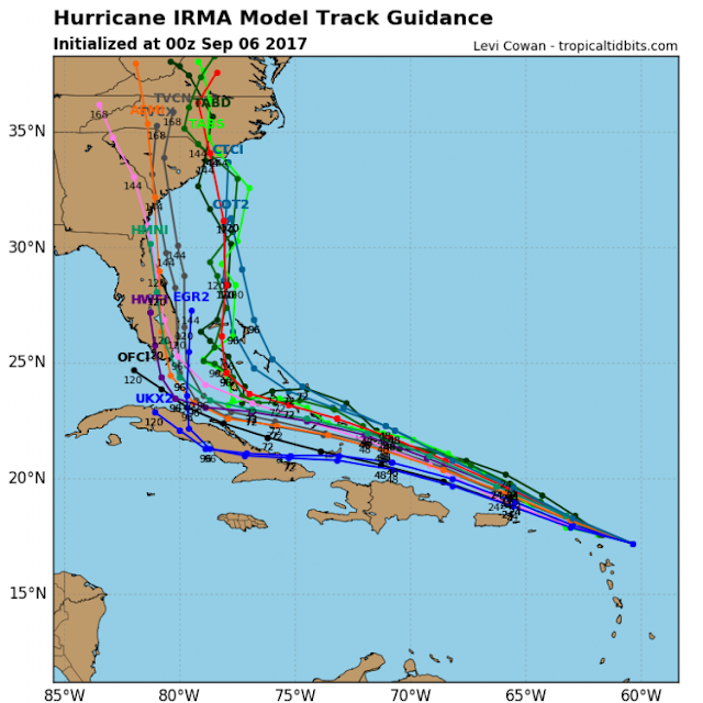
Every year, in the summer and fall months, the US east coast and gulf coast face a few tropical storms, as well as many other places. These storms start near the African coast of the Sahara Desert, travel across the Atlantic Ocean, and then make landfall with high wind and rain. Depending on how much moisture they pick up and where the landfall happens can determine how much damage they cause. With each storm, there comes a bevy of forecasts put out by different computer models. These forecasts begin about 10 days out and change as the storm gets closer and closer. This blog tries to extract some learnings from this process of forecasting. To explain the points, I am using screenshots from different hurricanes in the past.
Different methods lead to different forecasts
As one can see in the pictures (Source) below, there are a number of lines that show the forecast as generated by different models. (Hurricane Irma which made landfall in Southern Florida at 1 pm on the 10th of September 2017.) The first forecast is from the 2nd of September, and the second forecast is from the 6th of September. The different colored lines represent different forecasts as generated by a different computer or human models. The different models do not agree with each other, and the band of projection gets wider as one moves further away from the current location of the storm.


Forecasting lesson 1:
Almost all forecasts are precisely wrong, though many are correct enough to be useful. Try and find the ones that are correct and useful for your business.
Forecasting lesson 2:
Use the right model(s).
Forecasting lesson 3:
Consensus from different independent forecasts can be useful. Click the link to see consensus forecasts describing the different forecast methods. You might consider combining forecasts from independent sources by using simple or weighted averages.
Read More: Selecting the Appropriate Forecasting Method
Forecasting lesson 4:
Sometimes, there is no substitute for walking outside and seeing the conditions for yourself. Consensus should not be limited to the computer models and can include forecaster (human) input. Ensure you are encouraging people with ‘ears on the ground’ to provide input into your forecasting process.
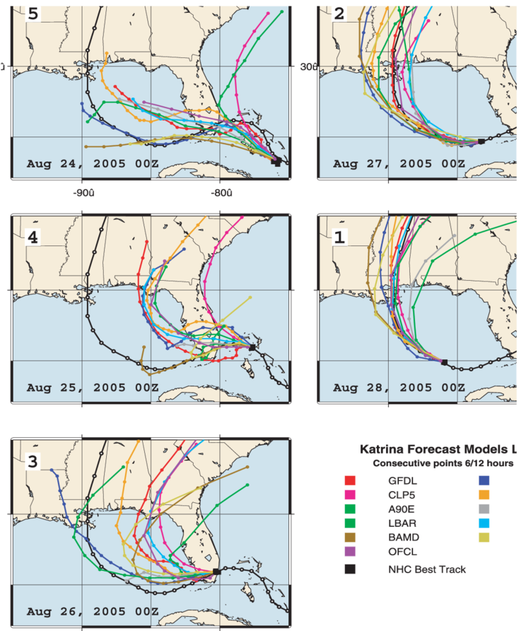
Forecast improves with more up to date data: As more data comes in (and as the eye of the storm gets closer to land), the models become better, though by no means perfect, in predicting where the landfall will occur. The pictures below (Source) are from Hurricane Katrina, which made landfall on the Gulf Coast on August 29, 2005. It is worth noting how the band narrows from August 24 to August 28.

Forecasting lesson 5:
Forecasts further out in time are less reliable than forecasts in the near future. Be aware of the prediction interval or the ‘cone of uncertainty’ related to your forecast. Be very clear about when the forecast is plan-worthy and when it is execution worthy.
Learn More: Top Forecast Accuracy Dashboard KPIs to Track On-Demand Webinar
Forecasting lesson 6:
A forecaster should not saddle themselves with the previous forecast. As new and better information comes in, one should be ruthless in discarding the old forecast and moving on to the newer, hopefully, better forecast.
Leadtime matters: For the person who finds themselves in the projected path of the hurricane, a key decision is when to move to a safer area. Given the changing forecast, it is quite natural to delay this move till the last possible moment. While this is OK to some degree, there comes a point of no return, after which the evacuation is not entirely possible. At that point, the only option is to ride out the storm. So, it is important to know the time by which you should decide to evacuate or stay put.
Forecast Lesson 7:
Know which forecast to hang your hat on. If you are getting material from China, and that has a 3-month lead time, there is no point in waiting for the very accurate forecast the month before as it is too late by then to get the product from China in time for the delivery to the customer.
Plan for Scenarios: Since there is a chance for the storm to go in places where it was previously not forecasted to go (within some limits of course), it would be advisable to plan and prepare for a possible impact as a just in case. In the worst case, there will be some extra supplies to work with over the next few weeks.
Read More: 6 Ways You Can Improve Forecast Accuracy with Demand Sensing
Forecast Lesson 8:
Understand that the future is uncertain, and all forecasts can have varying degrees of error in them. Plan for different eventualities by doing what-if scenarios as part of your planning process.
In summary, there is a lot to be learned about business forecasting from the field of weather forecasting. And perhaps the biggest lesson is that the forecast is often wrong, even when multi-million dollars’ worth of computer systems are at work. So do not lose hope and keep up the good work.
Enjoyed this post? Subscribe or follow Arkieva on Linkedin, Twitter, and Facebook for blog updates


